http://www.vnunet.com/vnunet/news/2214504/google-remolds-earth
take a read folks... Google Earth has added the street view (what everything actually looks like from ground view) and put in better (3D) navigation to the program.
So what's the big deal?
If you have a mobile device that can access the internet (pda/smartphone) who would need a GPS anymore? You can actually get turn by turn directions, see the actual buildings around you, and get the most accurate digital depiction of.. well.. the world.
But why would google use street view here.. I mean, we're just Randolph County right?
You'd be shocked and amazed folks. A little over a month ago, I noticed the odd elongated white van (with an omnidirectional camera) parked in the Walmart parking lot. It was actually parked in a space, thankfully. Sections of Asheboro are already on the google streetview layer.
This (I would imagine) is going to be applied on a global level too.. and for a simple blue-collar worker like myself, this allows us to see parts of the world that I may never be able to see. Imagine the benefit to school children. Why just talk about the pyramids or the Eiffel Tower when you can see it and the surroundings on the screen right in front of you... interactively.
I've used google earth to help me lay out some plans for the upcoming honeymoon. It can show you gas prices, hotels, things to do, restaurants... etc.
If you haven't yet tried this program, jump all over it here: http://earth.google.com/
I've yet to try out the plus version, but I'm half tempted to give it a shot.
8.27.2008
8.26.2008
too much sleep..
that's what I wish I could say I've had over the past few days, but it'd be a lie.
So hurray for Sagebrush and Timothy's.. oh.. and.. uh... Sherwood? Okay? I never figured Sherwood would be looking for beer sales, but more power to 'em... right? Maybe this will lessen the load on those overworked folks at RockOla. Seems that they've all been ridiculously busy and since the election was certified. Funny, sounds like someone may have been right about more money being spent in Asheboro.
I know I haven't picked up anything in Randleman since...
Wedding planning has been the word of the day since this past October, and the time is drawing much closer. Am I nervous? Not really. Is She? I hope not. I think it's a shared anticipation to have it behind us. There's nothing quite like spending 11 months trying to plan a wedding. Well, I take that back. There's nothing like having 11 months where you only really have about 4 months of time to use to plan a wedding.
The beauty, though, is that we'll be on our honeymoon in 2 weeks from right now. In fact, there should be sand between my toes in exactly 2 weeks. I'll be able to get back into Picasa and start add some pictures to the blog. Visual stimulation is always a plus in maintaining an audience. Well... pictures or sheer insanity.
Those of you that are fans of beer and head to/from Raleigh occasionally, stop in Apex at the Tyler's Taproom. I recommend Lion Stout or Great Divide Yeti Imperial Stout if you like a good dark beer that isn't local... oh, and have the Garlic Fries.
8.20.2008
"He gave up his ghost to heaven and we will miss him always"
I've spent years as a fan of the Dave Matthews Band... and I'm keeping that as a conservative description. As a musician, I kept it my goal to learn every song they've churned out... released, or unreleased.
It's hard to explain in a blog what the music that these guys produced has meant to me. It has pulled me through rough times and helped me celebrate wonderful little moments in my life... and one of the founding members of the band has left us.
One of the multi-instrumentalist for the Dave Matthews Band, LeRoi Moore, has passed away. He hadn't been on this past tour due to injuries that he received after an ATV accident in June. My fiancee and I attended a show on July 4th of this past year, and was astounded... as I tend to be at their shows.
We left the show, talking about the next one that we could go to. We left with a sense of anticipation and joy...

and it has since been, as of 8:12 this morning, completely emptied out with nothing to take its place.
what a sad, sad day.
Rest high above the clouds my friend, no restrictions.
It's hard to explain in a blog what the music that these guys produced has meant to me. It has pulled me through rough times and helped me celebrate wonderful little moments in my life... and one of the founding members of the band has left us.
One of the multi-instrumentalist for the Dave Matthews Band, LeRoi Moore, has passed away. He hadn't been on this past tour due to injuries that he received after an ATV accident in June. My fiancee and I attended a show on July 4th of this past year, and was astounded... as I tend to be at their shows.
We left the show, talking about the next one that we could go to. We left with a sense of anticipation and joy...
and it has since been, as of 8:12 this morning, completely emptied out with nothing to take its place.
what a sad, sad day.
Rest high above the clouds my friend, no restrictions.
8.19.2008
A few notes from the weekend..
- it's impossible to find the natural paper with embedded leaves/twigs/nature things.
- red robin charges way too much for a burger.
- carolina coffee always rises above my ridiculous expectations.
- tux fittings suck the life out of you.
- the lowes foods on 64 has the best beer selection in Asheboro.
- wisdom teeth are the devil.
- wheelies-shoes are sitting on the right hand of the devil known as wisdom teeth.
- everyone should follow the slow roma tomato roasting idea that Tom Gray posted
Everything else was a blazing success this past weekend though. I spent some free time putting together a template for the wedding programs... and we're getting everything in order. The marriage license is in hand, all we need now is to go through the motions and have everything signed.
As for the tomato roasting thing...
We played host to a few folks Sunday afternoon and I love putting together finger foods. I remember seeing the post that Tom had out and wanted to give that a try, so we popped a few slices of tomato in the oven. Instead of any sugar, I added two cloves of roughly diced garlic, olive oil, kosher salt, and cracked black pepper. They hung out in the oven for about 4 and a half hours instead of the full 12. While they did their thing, I pulled together a basil infused mayonaisse, toasted some sea-salt and rosemary bread, and sliced some polly-o mozzarella cheese.
They turned out to be, effectively, two-bite french bread pizzas.
Good stuff.
so with everything said and done, the wedding is a little over 2 weeks away... and our to-do list is shrinking daily.
...gah. I need a drink.
8.13.2008
working for the weekend
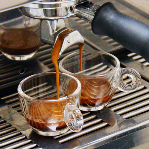
The very idea of starting off my saturday morning at Carolina Coffee and Tea is something that thrills me beyond compare. Being a coffee snob at heart, I've been hard-pressed to find a more outstanding cup of coffee anywhere around the Piedmont.
No, no... I'm not talking about Lattes or Cappucino.. I'm talking about a cup of coffee. Just hot, filtered water over freshly roasted and ground coffee beans. That is the essence of the cup. If you can't get a good cup of coffee, how can you expect a good latte? Just the same... I'm fully expecting a double espresso first, and a medium mild blend coffee afterwards.
...it's all about the crema. You won't find anyone at a big-box coffeeshop, or many mom and pop places that can pull a great shot of espresso. I could... but that's why I'm a snob now.
That would explain why I'm ridiculously happy about the espresso and coffee that I'll have Saturday... I know it's quality.
I get fitted for my tuxedo this weekend as well.
...and we put together wedding programs.
I'll try to get some pictures of the odd parking that we have now too, I'm tracking down the charger for my other digital camera.
With all of this to look forward too, I admit to working for the weekend as of this moment.
8.12.2008
who's next?
Any running bets on the next restaurant that will actually serve? There have been quite a few gas stations/locations for off-premises sales, but we've yet to see another restaurant jump on-board.
Who is going to give those hard working (a lot of wait-staff working double shifts, 7 days a week to accomodate the change) people at Rock-Ola a break?
Chilis?
Sagebrush?
San Felipe?
Burrito Brothers?
Timothys?
Something Different?
Pizza Hut?
Olde Towne Deli?
Bamboo Garden?
Blue Mist?
Mayflower?
Sapporo? (beer and sushi go well together...)
Tuscany? (Wine and italian food? who would've imagined!)
Quotables? (miiiiight have to stay open longer than just lunch though...)
Coaches?
Zekos? (beer and pizza work well too...)
Just a few examples to ponder...
I know Sir Pizza has vowed to never serve... and there are few places that I don't think would consider it. I've never seen alcohol served in a buffet style restaurant, and I really don't think many people want an Asheboro Libre with their Biscuitville bacon platter.
Just the same, who do YOU think is going to be the next to dive in?
8.11.2008
awkward parking in downtown...
Since when is it necessary to redo all of the parking downtown near Monroe's/the old courthouse? I can admit that the parking change near First Nation...er... Community One made a bit of a difference.
The biggest difference is not being able to see oncoming traffic until my car is halfway backed out onto Sunset Ave.
So why change things at the old courthouse/register of deeds? It's a blind turn and if you're the lucky winner of the "parking in the spot nearest the intersection", things may grow to be a bit hairy when backing out to leave. Does Asheboro need that much parking?
Pics to follow.
also, all four quik chek locations in Asheboro have their ABC permits... as well as both of the Lowes Foods stores.
8.08.2008
So aside from blogging, and enveloping myself in the hobbies that I listed on the brief self-description... I enjoy games. No, not mind games. Not drinking games, either. I'm a video game nut at times. I built the PC that I'm on now to the specifications that I wanted a few years ago, and would love to boost up a new machine overall. Some people argue about video game consoles. Not me, I've one of each... but the Wii sees more play time than the PS3. I haven't even hooked up the 360.
Tonight, it's PC gaming though. There's something addictive about first person shooters. I used to be a COD guy.. including all of the variants. I bounced around to BF2, Quakewars, Quake, Half Life2, and now back to Call of Duty 4.
I can't help it. I played "army" with my cousins 20 years ago... and don't care to enlist considering the current quagmire. Besides, digital bullets hurt much less... and are a lot cheaper too. Then there is the whole "hit enter to spawn again" deal that you can't really get in real life.
so hurray for the weekend. Yard work is waiting for me in the morning... and the poor yard needs it. The Fiance and I have been much too busy for our liking, so this could be both therapeutic and productive...
til then, folks.
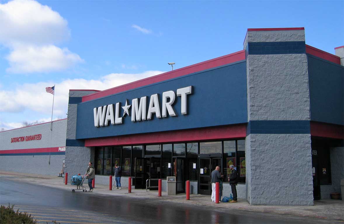
...and now Walmart gains their temporary permits. 
So I'm curious where all of the folks that were going to boycott alcohol-supporting business are going to shop now... I'm not trying to be facetious, just curious if these folks are going to stick to their testimony.
Both Wilco-Hess stations also picked up their permits yesterday. It will be interesting to see how these places change their layouts. What is going to go? I know that Lowes Foods (well, I've been told) is going to relocate their card section in order to put in new cooling units for their beer sales. I am just a bit curious about the walmart layout. Will they mimic that of the Randleman walmart? I've no idea.
I'd just be happy if they cleared the cars out of the fire lane/no parking zones.
Also, thank God it's Friday.
8.07.2008
the low price kings begin battle..
J&S Independent and 786 Mart both have their temporary permits. 786 Just picked theirs up a few minutes ago....
I just wish there was a station a little closer to downtown that could compete with those gas prices... whether they have beer or not.
I just wish there was a station a little closer to downtown that could compete with those gas prices... whether they have beer or not.
It may come as a shock...
...but my existence on Blogger isn't going to only revolve around alcohol, red oak, rockola, or abc permits. Just the same, as long as I can update that information, I will. However, there is a multitude of other things going on right now. For one, I'm within the 30 day countdown for my wedding... and in a month from this moment, I'll be on my way to Manteo for the beginning of the honeymoon.
It's been years since I've been to the banks, but the salt in the blood is rising with the anticipation. The last time I was there, I tried hanggliding. That didn't work out too well the first time around, but there's always hope. I just don't think I'm meant to fly.
I've been reading a ton of reviews and forum posts from roadfood, and I think that the honeymoon will be an adventure.
As a recommendation: If you've never been to the Beaufort Grocery restaurant in Beaufort, NC... please do.

8.06.2008
have a beer at Rockola...?
It was interesting to see the Red Oak van on the news last night... sitting out in front/beside of the Rockola.
My Fiance and I had our first date at the Red Oak Brewpub in Greensboro near Guilford College.
good times, good nachos, and great dark beer.
Hopefully the Easy Mart will have it... since they've applied for their permit.
http://www.ncabc.com/search/business.aspx?bid=148153
If they don't, I'm sure Food Lion won't let me down.
http://www.ncabc.com/search/business.aspx?bid=148164
then again, if they don't have the Red Oak beer, at least I can have a wine tasting at Oakie Mountain Shopping center.
or over at the other Food Lion on 49.. since they apparently have it permits too...
http://www.ncabc.com/search/business.aspx?bid=148166
that said, any of the 200 people that were at Rockola last night, what beers are they offering?
8.05.2008
and thus it begins.
as of 2:32PM, the July 29th ABC referendum has been certified. So who is heading out for that beer that Rockola has been waiting to sell since 1999?
...also, there have been no updates to the ABC Commission permit list.
Update.
Quick Quality Gas Station has been added to the list.
http://www.ncabc.com/search/business.aspx?bid=148144
...
Update.
Quick Quality Gas Station has been added to the list.
http://www.ncabc.com/search/business.aspx?bid=148144
so who is in? update!
http://www.ncabc.com/search/business.aspx?bid=79024
Rockola has acquired temporary permits to serve all four types of beverages. expect to see taps flowing soon.
http://www.ncabc.com/search/business.aspx?bid=148132
It would also appear the J&S Independent (of J&S Wholesale and Rentals, LLC) is in for all of the off premises sales optinos.
http://www.ncabc.com/search/business.aspx?bid=148144
And the Quick Quality Gas station on South Fayetteville Street is in for Malt Beverage and Unfortified Wine.
to echo this morning...
Election results will be certified within the next few hours.
Keep an eye on the NCABC commission website folks, I'm sure things are going to be showing up quickly. Also, the NCABC is hosting a RASP (responsible alcohol seller program) workshop on 8.14.2008 at the public works training room. 1312 N Fayetteville Street in Asheboro. There's a morning session from 10 am to noon, and an afternoon session from 1:30-3:30. The training is free...
it might not be a bad idea for prospective employees of Rockola/Chilis/Sagebrush/any future restaurants that might be opening to drop by and attend on of these seminars...
...but you have to register for the workshop.
ABC? Who's in?
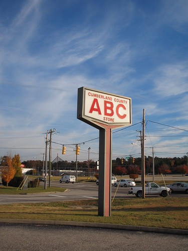
Aunt Betty's Cafe... The Alphabet Store...
I've heard it referred to as a few other code-names in my time, but the curiosity surrounding the ABC for today is simple... and has nothing to do with the retail location itself.
In the megalopolis that is Asheboro, who is applying for ABC sales and who isn't?
With the impending certification of the ABC referendum on tap (pun completely intended) to go through early this afternoon, there is an online database of all ABC permits that have been granted throughout the state for the past 15 years or so. The majority of permits have gone to individuals, but there have been a few businesses that have been listed as well.
The big news will be what names are being added to the list of permit applicants / temporary permit holders over the next 24 hours. It might make it a bit easier to squash those nasty little rumors floating around about who is and is not supporting sales of alcohol in asheboro.
curious? click here to search the database.
8.04.2008
So what are we looking for...?
I know there has been much in the way of assumption and supposition following the passing of the alcohol referenda here in Asheboro. A lot of folks are keeping their eyes peeled for what may be on the horizon for this sleepy city...
... so what is going on? What happens now? The election is to be certified within 16 hours and temporary permits will be assigned to local businesses. Rumor has it that Sagebrush, Rockola, Chilis, a few grocery stores, and convenience stores will be applying for temporary permits.
There's also a rumored sports bar and grille coming to the food lion shopping center on 49.
What would some of you like to see in the way of progress. I know there were a few good ideas posted on the highly commented on Randolph is Talking thread. Someone had mentioned the idea of a Microbrewery in Asheboro. A lot of folks shrugged off the idea, but take a look at Pittsboro. You'll find a microbrewery and a restaurant with an exceptional menu, live music three days a week, and ... of all things, a bar inside.
Could a brewery survive in Asheboro? It's possible. Probable? It's hard to say. One of my favorite breweries closed their restaurant in Greensboro. Red Oak Brewery is no longer open on the restaurant side of things, but they still sale and distribute their brews locally. If there was a tie in to the Zoo, and able to be sold to/from the local restaurants, a brewery could survive.
Me? I'd love to see a brewpub come into play. At one time, there was a coffeeshop downtown where Quotables is now. Bailey's Coffee and News was one of the closest thing to.. well.. if you ever watched Cheers... it was like that. Everyone that came in knew everyone else, and if a stranger walked in the door, they left as a friend. I'd love to have that aspect come back to somewhere here in town. Live music... open for longer hours...
...but that's just me.
Any word on the old Sir Roberts restaurant near the high school? Have any of you bloggers heard who is in contract with this particular spot? Color me curious.
also, what would you like to see move in to Asheboro now that the city is wet? Live music in the city park? Different restaurants? Where in Asheboro do you see the change?
the first of... many?
Well... here we are. Let's see how well I can keep up with this. After years posting to Livejournal, I'm going to try this particular flavor of blogging.
Thanks to Rob over at RIT for sparking the ever-present urge to blog.
Thanks to Rob over at RIT for sparking the ever-present urge to blog.
Subscribe to:
Comments (Atom)